Mount Monadnock NH Guide
Climbing 3,165-foot (965-meter) Mount Monadnock is a rite of passage for many New Englanders. It can be satisfying, but also dangerous. Here's what you need to know.
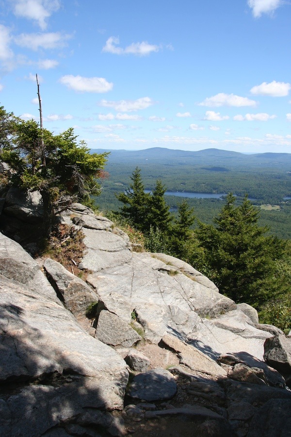
View from part way up the White Dot Trail.
About Mount Monadnock
Mount Monadnock, in southern New Hampshire off NH Route 124 between the towns of Jaffrey and Dublin (map), is the third most-climbed mountain on earth, following China's Tai Shan and Japan's Mount Fuji.
Each year, about 125,000 people make the 2-hour climb up Mt Monadnock, then the 2-hour descent to the base (4 hours total).
Mount Monadnock is located in Monadnock State Park, a 5000-acre (2023-hectare) reserve with camping, picnic and swimming areas, and 40 miles (64 km) of hiking trails .
What's a Monadnock?
Unlike Fuji's majestic volcano cone, Mt Monadnock is a bald dome of tortured metamorphic rock (schist and quartzite) smoothed somewhat by the glaciers that covered New England with a blanket of ice thousands of feet thick about 18,000 years ago.
Monadnock has been adopted as the American term for inselberg ("island mountain"), a mountain whose peak rises above the glacial ice flow surrounding it.
Mt Monadnock thus may have retained vegetation and features on its summit that predated the glacial age, but in the 1800s farmers set fire to forests on the mountain to flush out wolves.
The wolves were shot, the farmers' herds and flocks were protected, but destruction of trees on the summit led to erosion of the fragile soil covering, leaving the mountain with a summit of naked rock and an artificial tree line several hundred feet below the peak.
Any living sign of pre-glacial times was obliterated.
Regaining the Past
Trees are slowly creeping up the mountain as the soil is naturally replaced, but it will take centuries for nature to repair the damage and again cloak Monadnock completely in forest.
Another New Hampshire White Mountain with a similar history, also good to climb, is Cardigan Mountain east of Lebanon. More...
The View from the Summit
The view from the summit on a clear day is spectacular:
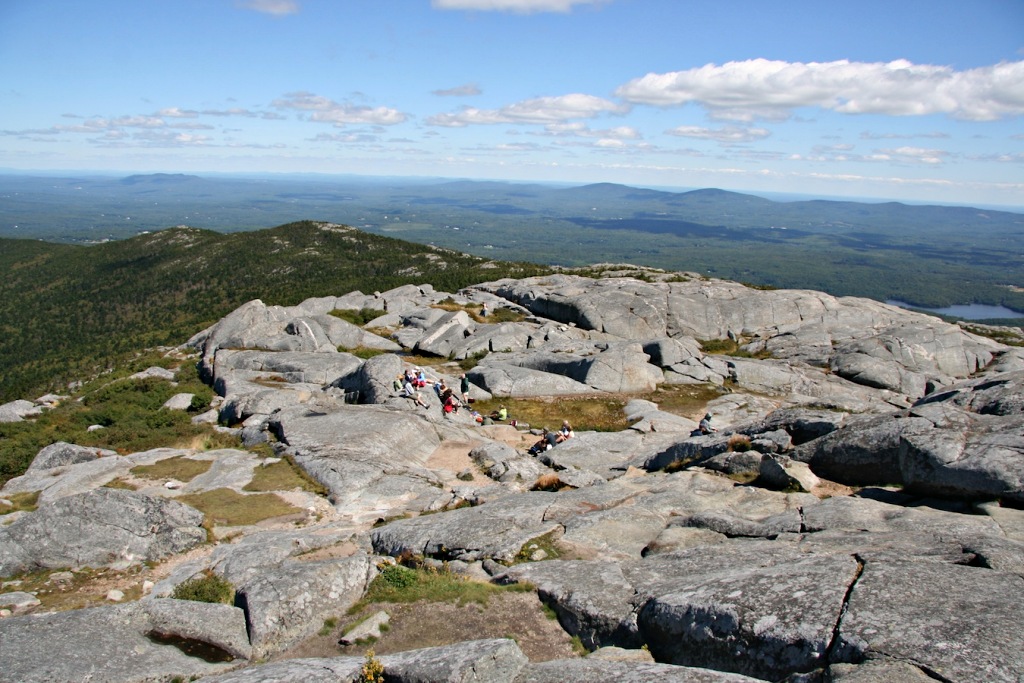
You can see all six New England states, and up to 100 miles (161 km) in all directions. (Note the tiny people in the photo above.)
How to Climb Mount Monadnock
Want to be among the 125,000 people who climb to the summit of New Hampshire's Mount Monadnock each year?
Good! The hike is exhilarating, the view from the summit worth the climb.
Rough Trails
But it is not an easy hike. The trails are not smooth paths, but mostly broken rock (stones the size of auto tires or larger). In some places you must climb rock slopes (no tools or ropes needed, though.) You must be agile, strong-legged, with strong ankles. (The chances of a turned, strained or sprained ankle are high.)
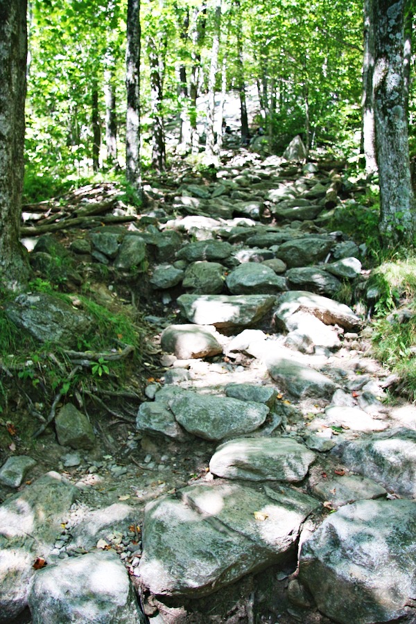
At Monadnock, they call this a "trail"!
You can approach and climb Mount Monadnock from any direction—north, south, east, west—but the shortest, quickest and most popular route is from the southeast via the Monadnock State Park headquarters off NH Route 124 (map),
White Dot Trail
You enter the state park, walk past the Visitor Center, and start up the mountain on the White Dot Trail, marked by signs, white dots on stones and, above tree level, by cairns (piles of stones), which are especially useful in winter when the white dots may be covered by snow.
Remember: there are no services whatsoever on the mountain! No water, food, shelter or communications.
After less than a half hour's walk, the White Cross Trail branches to the left (west) from the White Dot Trail. The White Cross Trail is marked by white crosses on rocks.
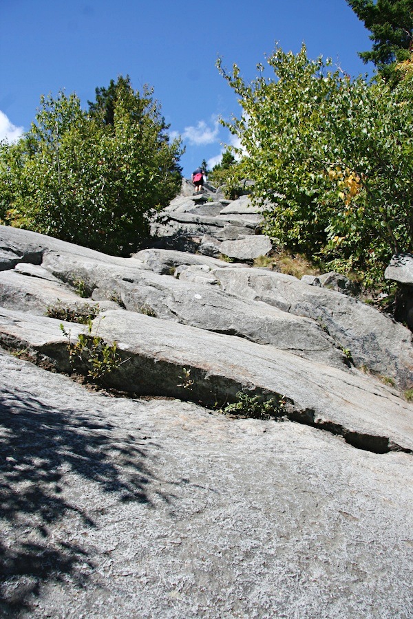
White Dot Trail climbs a rock face—and so do you. Note the small white dots on the rock, marking the way.
The White Cross is said to be less steep in places than the White Dot, but in fact both have steep places, and both are very rocky. The difference seems to come in the lesser number of steep rock faces on the White Cross (although there are still a few).
The two trails meet again above tree line and continue to the summit as the White Dot Trail.
Know Your Descent Trail!
Here's a warning that seems silly but is serious: be sure to descend the mountain on the same trail you ascended! Yes, it happens! Because the mountain has numerous trails to the summit, some hikers follow one trail up, and mistakenly follow a different trail down, reaching the base on the wrong side of the mountain. If your car is on one side and you are on the other side, at sunset, miles from your car, you may have no way to return to it except hiking for hours in the dark.
Click here to download a simple map of the trails (.pdf file, 2.6Mb).
Climbing Rules
Here's how to hike trails to the summit of Mount Monadnock pleasurably and safely:
1. Unless you're experienced hiking in winter weather, climb only in warm, fair weather (May to early October).
2. Allow at least two hours to climb to the summit from Monadnock State Park headquarters, and 1-1/2 to 2 hours to climb down. Four to five hours is the minimal reasonable time to make the complete hike, allowing some time to enjoy the view (and perhaps a picnic) at the summit.
If your party includes young children (1 to 8 years), older people (55+, that includes me), or anyone not in good middle-age physical condition, allow 5 to 6 hours or more.
3. Start your hike by lunchtime or earlier. Most enjoyable is to start after breakfast and reach the summit for a lunchtime picnic.
Plan to return to park headquarters at least 30 minutes before sunset, as the forest grows dark just after sunset, and picking your way across the trail's broken rock is tedious and dangerous, even with a flashlight.
4. Wear sturdy shoes, have sunblock for the hour or two above tree line, and carry extra clothing for the windy summit: at least a light jacket/windbreaker, perhaps also a sweatshirt or sweater. If the temperature is comfortable (mid-70°sF/ 20°sC) at the base of the mountain, it will be chilly because of the wind at the summit. If it's cool at the base, it will be cold at the summit. Don't spoil the pleasure of your time at the summit by not having sufficient clothing.
5. Carry at least one quart/one liter of drinking water per person, preferably more. Also carry snacks such as trail mix, nuts, fresh or dried fruit, candy bars, fruit juice and, if you wish, a picnic lunch. There are no services on the mountain: no food, no water, no shelter, no communications (although your mobile phone may work.)
6. Carry a trash bag and plan to carry out everything you bring to the park. Monadnock is a carry-in, carry-out park. There are no trash receptacles anywhere in the park! Whatever you bring in with you, you must take out with you, even banana peels, apple cores, etc.
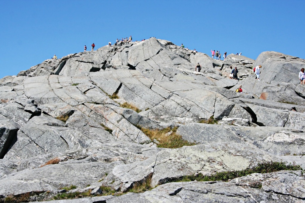
Hikers at the summit of Mount
Monadnock, New Hampshire.
Where to Stay
Jaffrey NH and surrounding towns and villages boast a number of rental cottages, homey B&Bs, motels and other lodgings. Use this Hotel Map with Prices to find just what you want:
