Downtown Boston Guide
Here's a guide to the center of Boston, the oldest, most historic district of the city.

Boston Common
Many colonial towns preserved a central public square for markets, meetings and militia drills, but Boston, founded in 1630 and soon the largest settlement in New England, had none.
Pasturing cows was more important to these early settlers. The Common was the colonial town's "common pasture land," to which any citizen could bring cattle—and still can. Today it's Boston's central park. Park Street Station, at the Common's northeastern corner, is the heart of Boston's MBTA subway system. The most central hotels for sightseeing are around or near the Common.
The Emerald Necklace
During its explosive growth in the 19th century, Boston's government was smart enough to hire famed landscape architect Frederick Law Olmsted, creator of New York City's beautiful Central Park, to make a master plan for Boston's green spaces.
Olmsted beautified the Common, preserving a colonial and early American cemetery near the corner of Tremont and Boylston streets, but adding statues, monuments and a Frog Pond that serves as a wading pool and fountain for children in summer, and as an ice skating rink in winter.
Bostron Common served as the city-center "anchor" for his masterpiece, the "Emerald Necklace," a chain of green spaces, old and new, six miles (10 km) long, from Boston Common and the newer Public Garden at the heart of the city, westward along Commonwealth Avenue in the Back Bay, then southward along the Back Bay Fens, and finally to Harvard University's Arnold Arboretum.
Public Garden
The Public Garden, adjoining the Common to the southwest (map), is the more formal portion of Boston's central park, with a curated variety of trees, carefully-tended flower beds, and a small "lagoon" on which the famous Swan Boats, cruise. No picnicking on the grass here.
Beyond the Public Garden to the west, the grand boulevard of Commonwealth Avenue, with its park-like central mall, extends westward through the Back Bay district.
Beacon Hill
North of Boston Common rises Beacon Hill, crowned by the Massachusetts state capitol, the Massachusetts State House.
Massachusetts State House
Home of the Great and General Court (the Massachusetts state legislature), dominates Beacon Hill and Boston Common with its gold dome. Located on the north side of Boston Common at the corner of Beacon and Park streets (map), it was the first building on Beacon Hill, which had earlier served as a cow pasture for governors of the colony.
Guided tours of the State House are conducted by volunteers every weekday from 10 am to 4 pm (closed weekends and holidays), and show you its Doric Hall, Nurses Hall, Hall of Flags, Great Hall, House of Representatives, Senate chambers and Executive Offices.
The rich marble decoration of the State House includes statues of important (and less important) historical figures, and glimpses of the state government at work.
Wandering Beacon Hill
Beacon Hill is Boston's finest residential neighborhood. The brick Federal-style houses are all superbly kept.
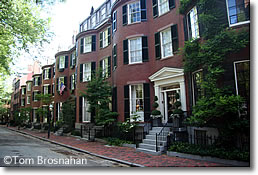
Stroll along Mount Vernon Street, the prettiest street on the hill. After a few minutes' walk you'll come to Louisburg Square (map), laid out in the 1840s with a tiny private park at its center. The square is Beacon Hill's architectural gem, and its most prestigious address. The park is owned in common by the residents of the houses facing the square.
Continue down the hill on Mount Vernon Street to West Cedar Street and turn left.
 |
|
| Louisburg Square on Beacon Hill: Boston's status address. |
The next street on the left is Acorn Street, a short street that is so photogenic it's almost synonymous with Beacon Hill. If you see a photograph of a Beacon Hill street, it's probably Acorn Street!
Continue to the next corner and turn right onto Chestnut Street, like Mount Vernon Street, lined with fine Federal brick row-houses.
If you're in need of a snack or drink, lunch or dinner, make your way to Charles Street at the western base of the hill, where there are shops, markets, boutiques, taverns and restaurants.
Downtown Crossing
Two short blocks southeast of Boston Common is Downtown Crossing, the intersection of winter, Summer and Washington Street (map) at the heart of Boston's department store and jewelry shopping district. It's easy to get to Downtown Crossing by subway to the Downtown Crossing station on the T's Red and Orange Lines.
Between West and Winter streets, Washington Street is a pedestrian zone. Jewelers are concentrated in the Jewelry Building at 387 Washington Street. If you're interested in bling, have a look: the building is filled with individual shops and millions worth of glitter.
Old South Meetinghouse is just two blocks north of Downtown Crossing along Washington Street.
South Station Transportation Center, with its train station and intercity bus terminal, is 3/10 mile (500 meters) southeast of Downtown Crossing.
Theater District
Just south of Boston Common, Boston's compact Theater District is packed with venues for plays, performances, comedy and entertainment of all types, as well as some good hotels.
Same-day half-price tickets for many Boston theater and musical performances are sold by BosTix online and at BosTix kiosks in Copley Square and Faneuil Hall Marketplace.
Financial District
South of Government Center, east of Downtown Crossing ,and south of Faneuil Hall Marketplace is Boston's Financial District of high-rise office towers and some good hotels. The skyscrapers tower above the Old State House.
The heart of the Financial District is Post Office Square, surrounded by Boston's most august financial institutions. Pretty Leventhal Park fills the center of the square, with a huge parking garage beneath.
The landmark Federal Reserve Bank of Boston, a skyscraping "steel radiator" of a building, marks the southern extent of the Financial District. It's located right across the street from South Station Transportation Center, and only a few minutes' walk from Chinatown.
Chinatown
A few blocks south of Downtown Crossing, near South Station and the Financial District, packed into the area around Beach Street, Tyler Street, and Harrison Avenue (map), are a dozen Chinese restaurants, groceries, and shops.
Like the North End, Boston's Chinatown is a place where the language of the old country may greet your ears more frequently than English.
Chinatown is particularly lively and fun at the time of traditional Chinese festivals and celebrations, when the dragons dance in the streets to the sound of thousands of little firecrackers detonated to scare off the demons.
Many Bostonians make the pilgrimage to Chinatown on Sunday to dine on dim sum, the seemingly endless succession of little delicacies served from carts circulating through the large dining room.
Dim sum is traditionally served from mid-morning to mid-afternoon. Come in, take a table and just point to dishes that look good. The serving will be added to your bill, and the total at the end of a long, delicious meal will be quite reasonable.
South Boston
Southeast of the Financial District across Fort Point Channel, South Boston has two distinct areas:
In the Seaport District you'll find the Boston Convention & Exhibition Center, Seaport World Trade Center, Flynn Cruiseport Boston, and a number of good hotels.
Boston Convention & Exhibition Center (BCEC)
The Boston Convention & Exhibition Center, in Boston's Seaport District, is Boston's newest and largest meeting, convention and exhibition facility. Several hotels are quite nearby.
The BCEC (BEE-see-EE-see) is just east across Fort Point Channel from the historic city center (map), and just west of Boston-Logan International Airport via the Ted Williams Tunnel.
In 10 or 15 minutes you can walk from the BCEC to Boston's wonderful Institute of Contemporary Art; Fort Point Channel with its HarborWalk; South Station Transportation Center for a train, bus or subway; Chinatown for dim sum; the Financial District; Downtown Crossing for shopping; and the Seaport World Trade Center for yet more exhibit space.
The MBTA station for Silver Line SL1 buses is between the BCEC and the Seaport World Trade Center, just a few minutes' walk from the front entrance of the BCEC.
MBTA buses 448, 449, and 459 also connect the BCEC to Logan Airport through the Ted Williams Tunnel/I-90 West, as do taxis and rideshare app cars. The trip takes only a few minutes.
"Southie"
South and east of the Seaport District is the center of South Boston, known as "Southie," traditionally Boston's Irish bastion, where St Patrick's Day (March 17th) is an official holiday.
Of course, it would not do for the City of Boston to officially celebrate an Irish religious holiday, so the subterfuge is that the celebration is for Evacuation Day. The British troops occupying colonial Boston were forced to evacuate the city on March 17, 1776 when American forces deployed cannons on Dorchester Heights in what is now Thomas Park.
Southie offers a long stretch of parks and sea beaches stretching for miles from Castle Island Park east and south all the way to the Bayside Exposition Center, John F Kennedy Museum and Presidential Library, and University of Massachusetts-Boston campus.
Note that South Boston is not Boston's South End, an entirely different residential district just south of Back Bay, separated from South Boston by the Fitzgerald Expressway (MA Route 3).
Boston Waterfront
East of Faneuil Hall Marketplace and south of the North End is Boston's Waterfront. The solid old brick and granite buildings which once served as warehouses for India and China traders have been modernized and converted to offices, shops, restaurants and apartments.
The New England Aquarium, Marriott Long Wharf Hotel and Boston Harbor Hotel are at the southern end of the Waterfront, and other hotels are available for your enjoyment.
You can easily walk to the Waterfront from the Financial District, Faneuil Hall Marketplace, Haymarket or the North End, or take an MBTA subway Blue Line train to the Aquarium station.
Government Center
Boston City Hall, state and federal offices are surrounded by Beacon Hill, the Financial District, Faneuil Hall Marketplace, and Haymarket Square.
Centerpiece of the goveernment complex is Boston City Hall (1968), a modern fortress-like structure designed by three college professors in the "brutalist" style that is as true to Boston's cultural and architectural traditions as a dumpster.
What a mess! The federal and state office buildings look straightforward enough—no architectural kudos, but they don't offend (except for the grotesque metal sculpture in front of the federal building which earns my award as World's Ugliest Public Monument. Your tax dollars at work!)
But Boston City Hall is a building only an architect could love.
The vast plaza, designed by I M Pei and known popularly as the "brick desert" for most of its life, has now been softened and made less desert-like with some trees, plantings and benches. But most people still march through it at top speed, as they do in all I M Pei plazas.
Luckily, the Sears Crescent (1840) on the south side of the plaza somehow survived the architectural jihad and now provides something pleasing to look at as you race across the plaza.
You'll probably see Government Center on your way to neighboring Faneuil Hall Marketplace, a triumph of historic preservation as urban renewal, thronged daily with people who like being there—just the opposite of Government Center.
On Friday afternoons and Saturdays, the Haymarket Square open-air fruit-and-vegetable market takes place just east of Government Center. That, too, is real life, untidy, but not purposefully ugly.
Faneuil Hall Marketplace
Boston's historic Faneuil Hall and Quincy Market complex has shops, takeout food stalls, cafés, good hotels, taverns and boutiques. Don't miss it.
Haymarket
The "square" is long gone, but Boston's big open-air food market still takes place here next to Faneuil Hall Marketplace, Government Center and the North End every Friday and Saturday.
On the east side of Government Center and the north side of Faneuil Hall Marketplace, just south of Boston's North End (map), Haymarket Square is the nondescript area where a busy open-air produce market is held each Friday afternoon and Saturday, rain or shine, all year long.
The Haymarket produce market is a welcome contrast to the more upscale offerings of the food shops, restaurants and boutiques of adjoining Faneuil Hall Marketplace.
The market is centered on short, narrow Blackstone Street (map). Most of the costermongers (vendors) are oldtimers from the North End's Italian community. Some have been working the market for decades, and some families have done it for generations.
Prices are much lower than in supermarkets. Haggling is sometimes possible, especially late in the day when prices fall as the sellers would rather sell than pack up, carry away and store what's left on the carts.
It's a colorful scene, and authentic. Most shoppers are not here to take photos but to shop for food for big families and to save money.
When I was a graduate student I would travel from Tufts University to Haymarket most Saturdays and carry home multiple bags of groceries, having paid about half of what they would have cost in the supermarket.
While you're here, have a look at the Union Oyster House at 41 Union Street, on the narrow street just to the west of the market (toward Government Center: map). The restaurant, established in 1826, is said to be "America's oldest restaurant."
TD Garden & North Station
The NBA's Boston Celtics basketball team and NHL's Boston Bruins ice hockey team pursue their victories in the 19,580-seat TD Garden arena at 100 Legends Way above North Station, less than a mile north of Boston Common.
Formerly known as TD Bank Garden, TD Banknorth Garden, Fleet Center, Boston Garden, etc., the arena has changed names over the years as "naming rights" were sold to the highest bidder.
(Compare this to Rome's Colosseum, which has had the same name for nearly 2000 years...)
The name and the signs change, the venue remains the same: home to two of Boston's proudest sports teams, and site of concerts by top-name touring stars and meetings and events of large groups.
The relationship between a huge concrete arena and a garden is and always has been a mystery. Colosseum, yes. Even Palaestra. But...garden?
Built above North Station, TD Garden is easily reached by MBTA Green Line subway trains, and by MBTA Commuter Rail trains on lines north and west of Boston, as well as Amtrak Downeaster trains to and from Portland, Maine.
North End
Home to successive waves of immigrants (most recently Italians), this is where you'll find Old North Church and Paul Revere's house.
The narrow streets and four-story brick buildings are now home to Italian-American families who preserve much of the old country's daily life in their Italian groceries, butcher shops, cafes, vegetable stands and restaurants.
Come to the North End to visit the historic landmarks, stop in for an espresso and a cannolli at one of the cafes or pastry shops, or even stay for lunch or dinner.
Hanover Street is the North End's "Main Street," lined with cafes, pastry shops and restaurants. Follow it north to St Stephen's Church, designed by famous Boston architect Charles Bulfinch. Turn left at the church into Paul Revere Park to reach Old North Church.
After visiting the church, walk up the hill in front of it on Hull Street to reach Copp's Hill Burying Ground, Boston's second-oldest cemetery with tombstones from the 1600s, 1700s and later. Then, enjoy the view all the way to Charlestown, Bunker Hill and the USS Constitution.