Finding Your Way in Boston
Downtown Boston is a maze of twisty streets difficult into negotiate in a car, easy to get lost in on foot. Here's a summary of major landmarks and districts to help you get oriented.
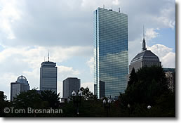
The mirror slab of the John Hancock Tower and the stolid rectangle of the Prudential Tower (to its left) tell you this is Boston's Back Bay.
Boston (map) has advantages: train and bus terminals are in the city center, and Logan Airport is less than a 15-minute taxi or subway ride from the center.
Downtown Boston
Boston Common
The heart of Boston—Boston's central park (map). Park Street Station, at the Common's northeastern corner, is the heart of Boston's MBTA subway system. The most central hotels for sightseeing are around the Common.
Public Garden
Just west of Boston Common (map), the formal Public Garden has the famous Swan Boats, some good hotels and, facing the Public Garden, the bar named Cheers.
Beacon Hill
On the northwest side of Boston Common, Beacon Hill is crowned by the Massachusetts State House (capitol) and narrow colonial streets lined with charming 18th- and 19th-century houses.
Downtown Crossing
Two short blocks southeast of Boston Common is Downtown Crossing, the intersection of winter, Summer and Washington Street (map) at the heart of Boston's department store and jewelry shopping district. It's easy to get to Downtown Crossing by subway to the Downtown Crossing station on the T's Red and Orange Lines.
Between West and Winter streets, Washington Street is a pedestrian zone. Jewelers are concentrated in the Jewelry Building at 387 Washington Street. If you're interested in bling, have a look: the building is filled with individual shops and millions worth of glitter.
Old South Meetinghouse is just two blocks north of Downtown Crossing along Washington Street.
South Station Transportation Center, with its train station and intercity bus terminal, is 3/10 mile (500 meters) southeast of Downtown Crossing.
Theater District
Just south of Boston Common, Boston's compact Theater District is packed with venues for plays, performances, comedy and entertainment of all types, as well as some good hotels.
Same-day half-price tickets for many Boston theater and musical performances are sold by BosTix online and at BosTix kiosks in Copley Square and Faneuil Hall Marketplace.
Financial District
South of Government Center, east of Downtown Crossing ,and south of Faneuil Hall Marketplace is Boston's Financial District of high-rise office towers and some good hotels. The skyscrapers tower above the Old State House.
The heart of the Financial District is Post Office Square, surrounded by Boston's most august financial institutions. Pretty Leventhal Park fills the center of the square, with a huge parking garage beneath.
The landmark Federal Reserve Bank of Boston, a skyscraping "steel radiator" of a building, marks the southern extent of the Financial District. It's located right across the street from South Station Transportation Center, and only a few minutes' walk from Chinatown.
Chinatown
A few blocks south of Downtown Crossing, near South Station and the Financial District, packed into the area around Beach Street, Tyler Street, and Harrison Avenue (map), are a dozen Chinese restaurants, groceries, and shops.
Like the North End, Boston's Chinatown is a place where the language of the old country may greet your ears more frequently than English.
Chinatown is particularly lively and fun at the time of traditional Chinese festivals and celebrations, when the dragons dance in the streets to the sound of thousands of little firecrackers detonated to scare off the demons.
Many Bostonians make the pilgrimage to Chinatown on Sunday to dine on dim sum, the seemingly endless succession of little delicacies served from carts circulating through the large dining room.
Dim sum is traditionally served from mid-morning to mid-afternoon. Come in, take a table and just point to dishes that look good. The serving will be added to your bill, and the total at the end of a long, delicious meal will be quite reasonable.
South Boston
Southeast of the Financial District across Fort Point Channel, South Boston has two distinct areas:
In the Seaport District you'll find the Boston Convention & Exhibition Center, Seaport World Trade Center, Flynn Cruiseport Boston, and a number of good hotels.
Boston Convention & Exhibition Center (BCEC)
The Boston Convention & Exhibition Center, in Boston's Seaport District, is Boston's newest and largest meeting, convention and exhibition facility. Several hotels are quite nearby.
The BCEC (BEE-see-EE-see) is just east across Fort Point Channel from the historic city center (map), and just west of Boston-Logan International Airport via the Ted Williams Tunnel.
In 10 or 15 minutes you can walk from the BCEC to Boston's wonderful Institute of Contemporary Art; Fort Point Channel with its HarborWalk; South Station Transportation Center for a train, bus or subway; Chinatown for dim sum; the Financial District; Downtown Crossing for shopping; and the Seaport World Trade Center for yet more exhibit space.
The MBTA station for Silver Line SL1 buses is between the BCEC and the Seaport World Trade Center, just a few minutes' walk from the front entrance of the BCEC.
MBTA buses 448, 449, and 459 also connect the BCEC to Logan Airport through the Ted Williams Tunnel/I-90 West, as do taxis and rideshare app cars. The trip takes only a few minutes.
"Southie"
South and east of the Seaport District is the center of South Boston, known as "Southie," traditionally Boston's Irish bastion, where St Patrick's Day (March 17th) is an official holiday.
Of course, it would not do for the City of Boston to officially celebrate an Irish religious holiday, so the subterfuge is that the celebration is for Evacuation Day. The British troops occupying colonial Boston were forced to evacuate the city on March 17, 1776 when American forces deployed cannons on Dorchester Heights in what is now Thomas Park.
Southie offers a long stretch of parks and sea beaches stretching for miles from Castle Island Park east and south all the way to the Bayside Exposition Center, John F Kennedy Museum and Presidential Library, and University of Massachusetts-Boston campus.
Note that South Boston is not Boston's South End, an entirely different residential district just south of Back Bay, separated from South Boston by the Fitzgerald Expressway (MA Route 3).
Boston Waterfront
East of Faneuil Hall Marketplace and south of the North End is Boston's Waterfront. The solid old brick and granite buildings which once served as warehouses for India and China traders have been modernized and converted to offices, shops, restaurants and apartments.
The New England Aquarium, Marriott Long Wharf Hotel and Boston Harbor Hotel are at the southern end of the Waterfront, and other hotels are available for your enjoyment.
You can easily walk to the Waterfront from the Financial District, Faneuil Hall Marketplace, Haymarket or the North End, or take an MBTA subway Blue Line train to the Aquarium station.
Government Center
Boston City Hall, state and federal offices are surrounded by Beacon Hill, the Financial District, Faneuil Hall Marketplace, and Haymarket Square.
Nearly a century ago, Boston's Scollay Square was where sailors and students would go to drink in taverns and watch vaudeville and burlesque shows.
It was rowdy. The city fathers (there were no city mothers at the time) hated it.
Urban renewal in the 1960s wiped Scollay Square off the map and replaced it with Government Center, a complex of federal, state and city government office buildings surrounding a vast 8-acre (3.2-hectare) brick-paved plaza.
Centerpiece of the complex is Boston City Hall (1968), a modern fortress-like structure designed by three college professors in the "brutalist" style that is as true to Boston's cultural and architectural traditions as a dumpster.
What a mess! The federal and state office buildings look straightforward enough—no architectural kudos, but they don't offend (except for the grotesque metal sculpture in front of the federal building which earns my award as World's Ugliest Public Monument. Your tax dollars at work!)
But Boston City Hall is a building only an architect could love.
The vast plaza, designed by I M Pei and known popularly as the "brick desert" for most of its life, has now been softened and made less desert-like with some trees, plantings and benches. But most people still march through it at top speed, as they do in all I M Pei plazas.
Luckily, the Sears Crescent (1840) on the south side of the plaza somehow survived the architectural jihad and now provides something pleasing to look at as you race across the plaza.
You'll probably see Government Center on your way to neighboring Faneuil Hall Marketplace, a triumph of historic preservation as urban renewal, thronged daily with people who like being there—just the opposite of Government Center.
On Friday afternoons and Saturdays, the Haymarket Square open-air fruit-and-vegetable market takes place just east of Government Center. That, too, is real life, untidy, but not purposefully ugly.
Faneuil Hall Marketplace
Boston's historic Faneuil Hall and Quincy Market complex has shops, takeout food stalls, cafés, good hotels, taverns and boutiques. Don't miss it.
Haymarket
The "square" is long gone, but Boston's big open-air food market still takes place here next to Faneuil Hall Marketplace, Government Center and the North End every Friday and Saturday.
On the east side of Government Center and the north side of Faneuil Hall Marketplace, just south of Boston's North End (map), Haymarket Square is the nondescript area where a busy open-air produce market is held each Friday afternoon and Saturday, rain or shine, all year long.
The Haymarket produce market is a welcome contrast to the more upscale offerings of the food shops, restaurants and boutiques of adjoining Faneuil Hall Marketplace.
The market is centered on short, narrow Blackstone Street (map). Most of the costermongers (vendors) are oldtimers from the North End's Italian community. Some have been working the market for decades, and some families have done it for generations.
Prices are much lower than in supermarkets. Haggling is sometimes possible, especially late in the day when prices fall as the sellers would rather sell than pack up, carry away and store what's left on the carts.
It's a colorful scene, and authentic. Most shoppers are not here to take photos but to shop for food for big families and to save money.
When I was a graduate student I would travel from Tufts University to Haymarket most Saturdays and carry home multiple bags of groceries, having paid about half of what they would have cost in the supermarket.
One hotel near Faneuil Hall Marketplace is right in the market. More...
While you're here, have a look at the Union Oyster House (Tel 617-227-2750) at 41 Union Street, on the narrow street just to the west of the market (toward Government Center: map).
The restaurant, established in 1826, is said to be "America's oldest restaurant." Here's the Union Oyster House's website.
TD Garden & North Station
The NBA's Boston Celtics basketball team and NHL's Boston Bruins ice hockey team pursue their victories in the 19,580-seat TD Garden arena above North Station, less than a mile north of Boston Common.
Formerly known as TD Bank Garden, TD Banknorth Garden, Fleet Center, Boston Garden, etc., the arena has changed names over the years as "naming rights" were sold to the highest bidder.
(Compare this to Rome's Colosseum, which has had the same name for nearly 2000 years...)
The name and the signs change, the venue remains the same: home to two of Boston's proudest sports teams, and site of concerts by top-name touring stars and meetings and events of large groups.
The relationship between a huge concrete arena and a garden is and always has been a mystery. Colosseum, yes. Even Palaestra. But...garden?
Built above North Station, TD Garden is easily reached by MBTA Green Line subway trains, and by MBTA Commuter Rail trains on lines north and west of Boston, as well as Amtrak Downeaster trains to and from Portland, Maine.
TD
Garden
100 Legends Way
Boston MA 02114
Tel: 617-624-1050
Customer Service Tel: 617-624-1331
customerservice@tdgarden.com
North End
Home to successive waves of immigrants (most recently Italians), this is where you'll find Old North Church, Paul Revere's house, and numerous good Italian restaurants, cafés and pastry shops.
Starting at the very northeastern tip of Boston's peninsula, the North End (map) is one of the city's oldest neighborhoods.
Old North Church ("One of by land, two if by sea") is its best-known landmark. More...
Paul Revere's House, the city's oldest house still standing, is another. It's located on pretty, cobbled North Square (map).
The narrow streets and four-story brick buildings are now home to Italian-American families who preserve much of the old country's daily life in their Italian groceries, butcher shops, cafes, vegetable stands and restaurants.
Come to the North End to visit the historic landmarks, stop in for an espresso and a cannolli at one of the cafes or pastry shops, or even stay for lunch or dinner.
Hanover Street is the North End's "Main Street," lined with cafes, pastry shops and restaurants. Follow it north to St Stephen's Church, designed by famous Boston architect Charles Bulfinch. Turn left at the church into Paul Revere Park to reach Old North Church.
After visiting the church, walk up the hill in front of it on Hull Street to reach Copp's Hill Burying Ground, Boston's second-oldest cemetery with tombstones from the 1600s, 1700s and later. Then, enjoy the view all the way to Charlestown, Bunker Hill and the USS Constitution.
Boston's North End is particularly lively during Italian church festivals, with decorations, processions and special events.
Charlestown
North of the tip of Boston peninsula are Bunker Hill and the USS Constitution ("Old Ironsides") in the old Boston Navy Yard.
North of the tip of the Boston peninsula, across the Charles River, is the mostly-residential district of Boston called Charlestown (map).
Landmarks: look for the Bunker Hill Monument at its highest point, and on the riverbank in the Charlestown Navy Yard (also called the Boston Naval Shipyard), the tall 18th-century masts of the USS Constitution ("Old Ironsides").
If you visit Old North Church in the North End, walk uphill to the old burying ground (cemetery) and look across the water to see Charlestown, marked by the Bunker Hill Monument, with Old Ironsides in the water below.
The USS Constitution is 2 miles (3.2 km; 42-minute walk) north of Boston Common, or 1.5 miles (2.4 km; 30-minute walk) north of Faneuil Hall Marketplace.
You can take the MBTA Orange Line subway to the Community College station in Charlestown, then walk a half-mile (800 meters, about 12 minutes) northeast up to Bunker Hill.
However, in summer you can take the MBTA F4 Ferryboat between Long Wharf (near the New England Aquarium and Aquarium Blue Line subway station) and Charlestown Navy Yard—and you get a mini-cruise of Boston Harbor as a bonus! More...
Back Bay
Developed on filled land during the 19th century and now one of the city's most important residential, business, entertainment and shopping districts, it includes Copley Square, Copley Place shopping complex, the Prudential Center ("the Pru"), Hynes Convention Center, and Newbury Street, good for shopping.
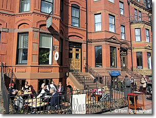
La Voile, a French restaurant on Newbury Street in Back Bay, Boston MA.
Boston's Back Bay, once a breadth of calm water in the Charles River, was filled with soil during the late 1800s so the city could expand westward from Beacon Hill and Boston Common (map).
Laid out with straight streets on a grid plan, the Back Bay became a prime residential and commercial area.
Today it has a large number of the city's best hotels. More...
Back Bay's main east-west residential axis is stately Commonwealth Avenue (map), which begins at the Public Garden and extends westward for several miles. In the Back Bay it is a shady mall—a narrow, extended park really—that's an important element in Frederick Law Olmsted's Emerald Necklace of parks and greenways extending through Boston.
To the north of Commonwealth Avenue and parallel to it are the residential thoroughfares of Beacon Street and Marlborough Street.
Back Bay's main east-west commercial axis is Boylston Street (map) to the south of Commonwealth Avenue, with shops, office towers, hotels and the Hynes Convention Center.
Newbury Street, between Commonwealth Avenue and Boylston Street, holds boutiques, restaurants and cafes, and stately old townhouses. It's the place for upscale boutique shopping, cafe-sitting and people-watching. More...
Back Bay Station, two blocks south of Copley Square along Dartmouth Street, just over the (underground) Massachusetts Turnpike (I-90), serves both Amtrak intercity trains and MBTA Commuter Rail suburban trains.
Charles River Esplanade
West of Beacon Hill, the Esplanade is a swath of green along the Charles River, with a boathouse and the Hatch Memorial Shell for open-air concerts.
The Charles River Esplanade (map) is the river's edge of Beacon Hill, on the north side. With its marina, the Hatch Memorial Shell for summer concerts, a bikepath, and lots of benches, it is the loveliest part of the Charles's banks.
The Hatch Shell is the setting for the Boston Pops' famous Fourth of July concert extravaganza, featuring Tschaikowsky's 1812 Overture accompanied by the firing of brass cannons and a stupendous fireworks display over the Charles River.
(If you decide to attend the concert and/or fireworks, stake out your space many hours in advance as the entire riverbank fills up well ahead of the concert.)
The Hatch Shell is also where the Boston Landmarks Orchestra and other groups perform free concerts and shows during the Landmarks Festival each summer. More...
The esplanade is bounded on the landward side by busy Storrow Drive, one of Boston's main traffic arteries. This major road cuts off the esplanade from most of Boston.
Access to the esplanade is by several pedestrian bridges that cross above the roadway.
For example, the Arthur Fiedler Footbridge takes pedestrians and bikers from Beacon Street across to the esplanade. From the Public Garden's northwest corner (Arlington Street and Beacon Street), walk northwest until you see the footbridge (map).
There is no parking available on the esplanade, although on summer Sundays the police sometimes allow parking on the north side of Storrow Drive which runs along the south side of the Esplanade.
Otherwise, you must park somewhere else in Boston and reach the Esplanade on foot or by bicycle.
Good places to park include at meters around the Public Garden (for a short Esplanade visit) or in the Boston Common Underground Garage beneath Boston Common (map) for a longer visit. Enter the Underground Garage by going north (it's one-way) on Charles St South.
If you intend to visit Cheers, imagined locus of the television show of that name, you can combine that visit with some time on the Esplanade.
Commonwealth Avenue
The wide, tree-lined monumental boulevard starting at the Public Garden is the main thoroughfare of the Back Bay. It goes west to Kenmore Square.
Boston's only boulevard in the grand European style, it is a beautiful link, through the Back Bay, in Frederick Law Olmsted's Emerald Necklace of Boston parks and gardens.
Boston is a city of districts and neighborhoods, with few grand boulevards.
The exception is the Back Bay district, which was a planned 19th-century development built on filled land.
Commonwealth Avenue, a wide, tree-lined divided boulevard, is the main thoroughfare of Back Bay, an important link in Frederick Law Olmsted's Emerald Necklace of green spaces extending from Boston Common for miles to the Arnold Arboretum.
Starting at the Public Garden, "Comm Ave" (as it's commonly called) extends southwestward for more than a mile, lined with grand townhouse mansions and studded with statues and benches. It ends at the Back Bay Fens, which extend the Emerald Necklace southward and westward toward Jamaica Plain.
Commonwealth Avenue defines the most graceful residential area of the genteel 19th-century Back Bay.
Beacon Street to the north, and Boylston Street to the south, are the other major east-west streets in Boston's Back Bay.
The shorter north-south streets of Back Bay that cross Cmmonwealth Avenue have been named in alphabetical order. Thus if you go westward along Commonwealth Avenue from the Public Garden you'll cross Arlington, Berkeley, Clarendon, Dartmouth, Exeter, Fairfield, Gloucester and Hereford before the system dies and you come to Massachusetts Avenue.
West of "Mass Ave" the greenery of Commonwealth Avenue continues for several more blocks through Charlesgate, which joins this link of the Emerald Necklace with the Back Bay Fens. More...
Newbury Street
Starting at the Public Garden by the deluxe Taj Hotel (formerly the Ritz) and extending westward through Boston's Back Bay (map), Newbury Street is the Boston byword for chic, trendy and stylish.
Premium international shops, choice local boutiques, art galleries, bistrots and cafés line both sides of the street, sharing space with graceful old residential stone-and-brick townhouses, some of which have been converted to office and/or retail space.
Vehicular traffic is one-way heading west on Newbury. There is some metered parking and a few small parking lots, but open spaces are rare during the busier times of the day and evening.
Newbury Street is a great place for a stroll. One way to do it is to take the MBTA subway Green Line train to the Hynes Convention Center station on Massachusetts Avenue (map).
Exit the station doors, turn right, then right again onto Newbury and stroll the mile (1.6 km) to Arlington Street and the Public Garden.
Walking fast, you can make it in 15 minutes, but the point is to walk slow and enjoy, so allow 30 to 50 minutes, more for shopping or a meal break.
If you have more time and want more variety, walk westward from the Public Garden along shady Commonwealth Avenue, admiring the beautiful Back Bay townhouses.
When you reach Massachusetts Avenue, turn left, walk south to Newbury Street and return eastward to the Public Garden.
Plan at least 45 minutes for this round-trip walk, more realistically an hour to an hour and a half, or even two hours if you shop and dawdle.
This walk is perfect if you're staying at the Taj Hotel or the Four Seasons Hotel, as you can start and end at your hotel. More...
Copley Square
Walking west from Boston Common for 10 or 15 minutes on Boylston Street in Back Bay brings you to Copley Square (map), at the corner of Boylston St and Dartmouth St, bounded by those streets and St James Avenue.
The square is framed by the classic Boston Public Library, the elegant Fairmont Copley Plaza Hotel, and Henry Hobson Richardson's famous Trinity Church, built in the late 1800s.
Other hotels are concentrated in this prime office and shopping area as well. More...
Part of the square is a pretty, green, partly shady park with a pool, flowerbeds and benches.
Modern intruders on this gentility are the striking mirror-glass shaft of the John Hancock Tower and, a block west, the sprawling office-and-shopping complex called Copley Place.
On the west side of the Boston Public Library is the John B Hynes Veteran's Memorial Convention Center, the smaller of Boston's two official convention centers (the larger one being the Boston Convention & Exhibition Center in the Seaport District of South Boston. More...)
North of Copley Square along Clarendon and Dartmouth streets is Newbury Street, with its boutiques and sidewalk restaurants, and beyond that Commonwealth Avenue.
All trains on the MBTA subway's Green Line, eastbound and westbound, stop at the Copley Square station. After Copley, westbound B, C, D and E trains follow different routes to their destinations.
Prudential Center
Opened in 1964, Boston's Prudential Center is an office tower, hotel and shopping complex on Boylston Street just west of Copley Square in the Back Bay near the Hynes Convention Center (map).
Bounded by Boylston Street, Huntington Avenue and Dalton Street, the Prudential Center is built in part) above the Massachusetts Turnpike (I-90). The Prudential Tower, centerpiece of the complex, is a rectangular 52-storey skyscraper that, with its antenna, is the tallest building in Boston, inching above the nearby John Hancock Tower.
Unless they're staying in the Sheraton Boston Hotel in the complex, most visitors to "the Pru" come to visit the Prudential Skywalk Observatory observation deck on the 50th floor of the Prudential Tower, the tallest observation deck in New England.
The Top of the Hub Restaurant on the 52nd floor enjoys the same panorami view. There's no fee to enter the restaurant, but you're expected to sit and drink and/or dine.
Many also come to shop in The Shops at the Prudential Center, spread throughout the complex. The more than 75 shops and restaurants include Barnes & Noble, The Cheesecake Factory, Lacoste, Legal Sea Foods, P.F. Chang's China Bistro, Saks Fifth Avenue and Sephora.
The Shops at the Prudential Center are connected by an elevated, glass-enclosed pedestrian walkway to the Copley Place complex on the east side of Huntington Avenue.
Boston Duck Tours start their jolly amphibious-vehicle city tours from the Prudential Center. You can buy your tickets here.
To reach the Prudential Center by subway, take an MBTA subway Green Line train to the Copley Square station, the Hynes Convention Center station, or the Prudential Center station. The center also has a large underground parking garage.
You might want to consider including a stop at the Prudential Center in your Back Bay walk along Commonwealth Avenue and/or Newbury Street.
Prudential Center
800 Boylston Street (map)
Boston MA 02199
South End
Not to be confused with South Boston, the South End is a pretty 19th-century residential neighborhood with lots of good restaurants, cafés and bars.
Boston's South End, the district southeast of Huntington Avenue between Berkeley Street and Massachusetts Avenue (map), was once a tidal marsh, but during the 1800s it was filled with gravel to expand the land area of Boston.
(The Back Bay is also filled land, but most of the South End was filled before the Civil War (1861-1865), and most of Back Bay was filled afterwards.)
The South End (not to be confused with South Boston) is mostly residential, with harmonious five-story red brick buildings in a variety of architectural styles including Second Empire, Italianate and Renaissance Revival. You'll see a lot of fine bow-front buildings here (compare those on Louisburg Square on Beacon Hill).
Blackstone Square and Franklin Square are the South End's two city-block parks, shady refuges on the north and south sides of Washington Street at W Newton Street.
The district also has eleven "residential parks," one-block-long public gardens at the center of a divided street framed by townhouses. Union Park is perhaps the best exemplar.
If you don't live in the South End, what's it good for?
Restaurants!
The urbanites who live here love to dine out, and Columbus Avenue (MA Route 28) has numerous good bistros, bars and cafes.
Although the northern edge of the South End is only about five blocks south of the Public Garden (map), the neighborhood is somewhat cut off from downtown Boston by the urban canyon built for the Massachusetts Turnpike (I-90). You cross the canyon via Tremont Street, Columbus Avenue and Huntington Avenue.
To get to the South End by subway, take an MBTA subway Orange Line train to Back Bay station (which is also served by Commuter Rail trains.)
For more on the South End, have a look at
the South
End Historical Society website.
Huntington Avenue
Southwest of the Pru, Huntington Avenue passes the Christian Science Church Center, Symphony Hall, Northeastern University, and the Museum of Fine Arts.
Huntington Avenue is nicknamed Boston's Avenue of the Arts.
Starting in Copley Square and heading diagonally southwest through the city, Huntington Avenue (MA Route 9) and the MBTA subway's Green Line E trains ("Heath Street") that run along it, take you to all these institutions:
Christian Science Church Center
Known for its plaza and reflecting pool, the Mother Church and Mapparium, and elegant Reading Room. More...
Symphony Hall
Home of the Boston Symphony Orchestra, Symphony Hall, 301 Massachusetts Avenue at Huntington Avenue, also hosts many other headline musical performances.
Berklee & New England Conservatory
The New England Conservatory at 290 Huntington Avenue offers many performances by students, faculty and visiting artists.
Northeastern University
Known for its programs in experiential education (learn by doing), Northeastern has a prime location among Boston's arts institutions at 360 Huntington Avenue.
Museum of Fine Arts
Boston's largest and most renowned collection of paintings, sculpture and historic art objects, the "MFA's" campus is a landmark at 465 Huntington Avenue. More...
Isabella Stewart Gardner Museum
Though located a few blocks off Huntington Avenue, the Gardner is easily visited in combination with a visit to the Museum of Fine Arts. More...
Massachusetts College of Art & Design
Among Boston's most prominent art schools, MassArt at 621 Huntington Avenue has its own exhibits, tours and talks.
Kenmore Square
Boston University is a few blocks west, smaller colleges are closer, so Kenmore has good hotels, cafés, bookstores, cinemas, and clubs.
Kenmore Square is a Boston landmark at the western end of Commonwealth Avenue's parklike extent. (Comm Ave continues westward, but without the trees that make it part of the Emerald Necklace.)
On the Boston skyline at night, you can always locate Kenmore Square by the huge red Citgo delta sign.
With Boston University just to the west, Kenmore is enlivened by students and professors who flock to its cafés, bookstores, movies, and clubs.
Fenway Park, home of the Boston Red Sox baseball team, is just to the south of the square, which you can readily realize on any summer night when there's a game being played: you'll see the lights and hear the noise.
Here are hotels near Fenway Park.
To get to Kenmore Square by subway, take any Green Line B (Boston College), C (Cleveland Circle) or D Riverside) train to the Kenmore station.
Back Bay Fens
An uninviting name, but a beautiful park that's an essential link in Frederick Law Olmsted's "Emerald Necklace," Boston's seven-mile string of parks and green spaces.
The name covers a lush serpentine park framed by cultural landmarks, an essential link in Frederick Law Olmsted's Emerald Necklace of Boston parks & gardens.
The Back Bay Fens sound uninviting, but actually this unappetizing name designates a pretty park that is an important link in Frederick Law Olmsted's Emerald Necklace, a chain of green parks, copses, and waterways for the residential districts of Boston from the Boston Common and Public Garden, through the Back Bay and Roxbury to the Arnold Arboretum in Jamaica Plain (map).
The Fens are the southward and westward continuation of the Emerald Necklace, joining the western end of Commonwealth Avenue.
Even though the Fens are bounded by busy streets—The Fenway and Park Drive—the Fens provide welcome greenery views to the people living in the stately stone and brick residential buildings that frame the parkland.
Just west of the northern end of the Back Bay Fens is famous Fenway Park, home of the Boston Red Sox baseball team.
On the opposite (east) side of the northern end of the Fens is the Boston Conservatory of Music.
At the southern extent of the Fens are Boston's renowned Museum of Fine Arts, the Isabella Stewart Gardner Museum, Simmons College, Emmanuel College and Wheelock College.
Roxbury
Once an incorporated city in its own right, Roxbury is now the center of African-American culture following the migration of people from the southern states during the 1940s and 1950s, joined later by immigrants from the Caribbean.
The 527-acre (213-hectare) Franklin Park, Boston's largest, is in Roxbury, the final "link" in Frederick Law Olmsted's Emerald Necklace of parks and shaded avenues extending from Boston Common through the city.
Around Boston
East Boston
Home to Logan Airport, this district northeast of Charlestown, is reached by three tunnels: Callahan Tunnel north, Sumner Tunnel south, and Ted Williams Tunnel (both directions).
East Boston, where you'll find Boston-Logan International Airport, is northeast of Charlestown (map).
The district and the airport are reached by three tunnels from Boston:
—Callahan Tunnel runs north, outbound from Boston near Faneuil Hall Marketplace to East Boston, no toll
—Sumner Tunnel runs south, inbound from East Boston to Boston, toll)
—Ted Williams Tunnel carries the Massachusetts Turnpike (I-90) underneath Boston Harbor from South Boston directly from South Boston and the Boston Convention & Exhibition Center to Logan Airport (map).
The "T" Blue Line subway also connects the center of Boston with the airport. Take the Blue Line train (from Government Center, for example) to the Airport station.
Cambridge
Across the Charles River is the separate City of Cambridge MA, with its world-famous universities: Harvard and the Massachusetts Institute of Technology, plus its own selection of good hotels. More...
Brookline
A large, mostly residential city, former hometown of the Kennedy family, Brookline is a separate city surrounded by Boston.
The city of Boston extends south from its historic center on the peninsula for miles, but go several miles west from the historic peninsula and you bump right into Brookline.
Brookline is a separate municipality, a mostly residential city that interrupts Boston's westward march, extending from Boston University on the southern bank of the Charles River southwestward to the city of Newton. Brookline is completely surrounded by Boston and Newton.
The Fenway, Jamaicaway and Olmsted Park, elements in Frederick Law Olmsted's Emerald Necklace of greenery, separate Boston and Brookline at the north. The Frederick Law Olmsted National Historic Site is south of Boylston Street (MA Route 9) in Brookline.
Larz Anderson Park in southern Brookline holds the Larz Anderson Car Museum, once known as the Museum of Transportation.
Known for its gracious old houses and estates, Brookline boasts a number of distinguished residents and former residents, including architect Henry Hobson Richardson, landscape architect Frederick Law Olmsted, President John Kennedy and other members of his family, and Boston Symphony Orchestra conductor Serge Koussevitsky and Boston Pops conductor Arthur Fiedler.
Today it's a favorite nesting-ground for Boston's academic community: professors from Harvard, MIT, Brandeis and other institutions of higher learning.
Brookline is also full of doctors and other medical personnel, as the Longwood Medical Area extends from Boston into Brookline along Longwood Avenue.
Somerville
North of Cambridge, Somerville is largely residential, and home to parts of Tufts University.
Most people know that Cambridge, Massachusetts is the city on the far side of the Charles River from Boston (map).
Somerville MA is Cambridge's neighbor city to the north, one of the separate municipalities that make up Greater Boston.
Mostly residential, Somerville is a mostly working-class city that is also home to many university students, some attending universities and colleges in Cambridge, others enrolled at Tufts University, the campus of which is partly in Somerville and partly in Medford MA.
The Powderhouse in Powderhouse Square (map) near Tufts, was constructed as a windmill in 1703-4 by John Mallet. In 1747 it was deeded to "the Province of the Massachusetts Bay in New England," and was used thereafter most often as a storage place for gunpowder, including by the American army besieging Boston.
If you'd like to visit it, take the MBTA Red Line subway train to Davis Square station and walk for 10 minutes along College Avenue to Powderhouse Park (map). Tufts is just beyond the park.
Out of Boston
You can use Boston as your base for day-trips and overnight excursions to nearby towns such as Concord, Gloucester, Ipswich, Lexington, Plymouth, Quincy, Rockport, Salem, and even Cape Cod. All are accessible by MBTA Commuter Rail train, MBTA Greater Boston bus, or intercity bus. More...